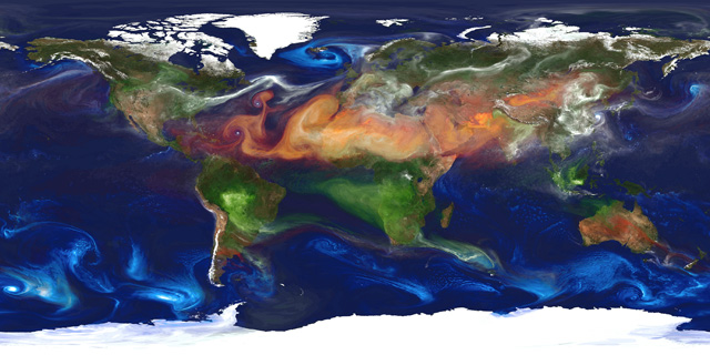
NASA computed Maps of Earth

Die NASA hat sich ‘nen neuen Supercomputer angeschafft und simuliert mit dem die Erde, heraus kommen zum Beispiel so schicke Karten wie das Ding oben, und das Teil ist keinFoto, sondern ‘ne berechnete Grafik. Whoa!
This is not a photo of the Earth from some far-flung satellite. This is the output of a computer that has been programmed to take those laws of physics and apply them to the Earth. It has data about sunlight hitting the Earth (which includes variations for season); it knows about the composition of the Earth’s atmosphere and how the air’s temperature changes with latitude, longitude, and height; it can calculate how much water evaporates and where it rains or snows out; it accounts for fires, dust, the Earth’s rotation, the local geography, and even humanity’s effect on the environment.
And when it’s done, it can show us what the Earth looks like under various conditions. In this case, the blue swirls over the oceans trace sea salt; green is smoke from forest fires, white is sulfate particles (emitted from volcanoes and the burning of fossil fuels), and reddish-orange is dust blown about. Slate Link
Planet in a Bottle: NASA creates computer model of dust storms, forest fires, and sea salt.