Virginia Lawmaker Says ‘Sea Level Rise’ Is A ‘Left Wing Term,’ Excises It From State Report On Coastal Flooding

Virginia Lawmaker Says ‘Sea Level Rise’ Is A ‘Left Wing Term,’ Excises It From State Report On Coastal Flooding

Virginia’s legislature commissioned a $50,000 study to determine the impacts of climate change on the state’s shores. To greenlight the project, they omitted words like “climate change” and “sea level rise” from the study’s description itself. According to the House of Delegates sponsor of the study, these are “liberal code words,” even though they are noncontroversial in the climate science community.

Instead of using climate change, sea level rise, and global warming, the study uses terms like “coastal resiliency” and “recurrent flooding.” Republican State Delegate Chris Stolle, who steered the legislation, cut “sea level rise” from the draft. Stolle has also said the “jury’s still out” on humans’ impact on global warming:

State Del. Chris Stolle, R-Virginia Beach, who insisted on changing the “sea level rise” study in the General Assembly to one on “recurrent flooding,” said he wants to get political speech out of the mix altogether.

He said “sea level rise” is a “left-wing term” that conjures up animosities on the right. So why bring it into the equation?

“What people care about is the floodwater coming through their door,” Stolle said. “Let’s focus on that. Let’s study that. So that’s what I wanted us to call it.”

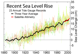
There is a resistance to calling science what it is, even in the studies commissioned to investigate the impact of climate change. The reality is that coastal cities are spending millions to respond to rising sea levels, like Norfolk, Virginia. Norfolk spends $6 million a year to elevate roads, improve drainage, and help homeowners raise their houses, according to BBC. Already, 5 percent to 10 percent of the city’s lowest-lying neighborhoods have heavy flooding. The world’s largest naval base, based in Norfolk, is spending hundreds of millions to replace piers to withstand rising water. Yet they manage to make no mention of climate change or sea level rise in their response strategy.

Modeling H2S in InfoSWMM

Subject:   Modeling H2S in InfoSWMM 


You can model Sulfide in InfoSWMM using the H2S water quality modeling option which uses BOD5 loading at nodes to estimate the  S concentration in the nodes and links of the network using constant network parameters for: 


 1.        The Reaction Rate Coefficient,

2.       The Sulfide Loss Coefficient,

3.       Sulfide Flux Coefficient,

4.       Temperature in Degrees C,

5.       Soluble Sulfide Percentage,

6.       pH for the whole network, and

7.       The Ionization Constant. 


Relationship between BOD5 and EBOD 


 Figue 1.  The concentation  of H2S and BOD5 can be graphed at each node and link.

Figure 2.   Dialogs for H2S and BOD5 in InfoSWMM

Mass Balance for Water Quality in SWMM 5

Subject:   Mass Balance for Water Quality in SWMM 5 


The rainfall concentration is listed in the wet deposition row of the Runoff Quality Continuity Table, the washoff such as EMC washoff is listed in the Surface Runoff row.  If you are simulating groundwater quality then it is listed as a separate value in a row of the Quality Routing Continuity table alongside RDII quality, DWF quality and WWF quality. 

Country of Samoa Chooses Innovyze Smart Water and Sewer Network Modeling Solutions

Country of Samoa Chooses Innovyze Smart Water and Sewer Network Modeling Solutions

Samoa Water Authority Selects H2OMAP Water and InfoWorks CS

Broomfield, Colorado, USA, May 29, 2012

Innovyze, a leading global innovator of business analytics software and technologies for wet infrastructure, today announced that the Samoa Water Authority (SWA) has chosen Innovyze industry-leading H2OMAP Water and InfoWorks CS software for water distribution and sewer collection modeling and design of the Samoan network. The selection further substantiates Innovyze’s leadership position in geospatial hydraulic infrastructure modeling and management across the globe.

Established in September of 1993, the SWA is the national supplier of water services to Samoa’s 180,000 citizens. The authority manages five conventional slow-sand filter water treatment plants and five newer rapid-sand filtration package treatment plants. All treated supplies are chlorinated to comply with the Samoa National Drinking Water Standards. Customers served by these treatment plants enjoy safe, quality water on a 24-hour basis if the supply is sufficient. Customers whose water is drawn from springs and river intakes also receive a constant supply, but the water is untreated and not disinfected. Customers served by wells receive intermittent supply determined by the pumping hours of their specific well.

H2OMAP Water is a powerful and practical geographic information system (GIS) platform for water utility solutions. As a stand-alone GIS-based program, it combines spatial analysis tools and mapping functions with sophisticated and accurate network modeling for complete infrastructure management and business planning. H2OMAP Water performs fast, reliable, and comprehensive hydraulic and dynamic water quality modeling, energy management (with true variable speed pumping), real-time simulation and control with online supervisory control and data acquisition (SCADA) interface, and complete fire flow and carbon footprint analyses.

“The H2OMAP Water and InfoWorks CS software was recommended by key designers whom undertook the Authority’s Water Supply and Sanitation master plan. SWA used other software packages previously, but these were superseded or suspended due to incompatibility with existing GIS software. Innovyze solutions were selected as they can incorporate Epanet, Mapinfo (GIS) data and AutoCad,” said Tafeamalii Philip Kerslake, Technical Manager of SWA. “Using their advanced hydraulic modeling applications will allow us to troubleshoot our complex problem areas and allow us to evaluate different operating scenarios — ultimately leading to a more efficient system and better customer service.”

H2OMAP Water fully supports geocoding and multiple mapping layers, which can be imported from one of many data sources including computer-aided design (CAD) drawings (e.g., dwg, dgn, dxf); CAD world files; standard GIS formats (Shapefiles, MID/MIF files, and ArcInfo coverages); Vector Product Format (vpf) files; Spatial Database Engine (ArcSDE) layers; attribute tables; grid data; image files; open database connectivity (ODBC); and Comma Separated/Delimited Text (CSV) files. The program also supports the geodatabase standard of ArcGIS through an ArcSDE connection.

InfoWorks CS provides wastewater utilities with a uniquely effective tool for undertaking hydrological modeling of the complete urban water cycle. Essential for identifying and justifying cost-effective infrastructure improvements, InfoWorks CS also offers a practical method for operational control (including real-time control) of the sewer network. Other applications include urban flooding and pollution prediction and the modeling of water quality and sediment transport throughout the network.

In addition to supporting fast and accurate network modeling, InfoWorks CS features specific tools to support the modeling of subcatchment takeoff and infiltration. With its exceptionally fast and robust simulations, the software facilitates the swift modeling of total networks or any subnetwork.

“The adoption rate of Innovyze technology across the industry reflects a powerful trend among water and wastewater utilities toward our products,” said Andrew Brown, Innovyze Director of International Operations. “The shift is being driven by a range of compelling advances, including speed; brevity of learning curve; dynamic, comprehensive feature sets; and superior technical support. We are pleased to see the Samoan Water Authority and other progressive utilities continue to expand their commitment to using world-class software tools to benefit their customers.”
Saving to previous versions of ArcGIS in InfoSWMM and InfoSewer

Saving to previous versions of ArcGIS in InfoSWMM and InfoSewer

Once you open and save an existing map document (.mxd file) using ArcGIS 10, the map can no longer be opened with earlier versions of ArcGIS because it will now reflect the new functionality added at 10. Similarly, new documents you create with 10 also cannot be opened in earlier versions of the software. However, you can use the Save A Copy command to make a copy of a map document so you can open and work with it in previous versions of ArcGIS. With ArcGIS 10, you can save to ArcGIS 9.3, 9.2, 9.0/9.1, or 8.3. ArcGIS 9.0 and 9.1 map documents are directly compatible with each other and those versions of the software.

Each new version of ArcGIS introduces functionality and properties that aren't available in previous versions. When you save a map document, layer file, or 3D document to a previous version of ArcGIS, the format of the file is changed to eliminate properties not available in the older version.

This means saving from 10 to a previous version removes from the file any functionality that depends on the newer software in ArcGIS 10. Therefore, some work may be lost if you save to 9.3, 9.2, 9.0/9.1, or 8.3 and start working with the older copy again in 10, since the 10 functionality was stripped out in the Save A Copy process. Your original ArcGIS 10 file will still have the new functionality.  Source http://help.arcgis.com/en/arcgisdesktop/10.0/help/index.html#//006600000253000000.htm